G.3 On Borders’ Cartographical Representations: Problematics of the Past and the Present
Sat Oct 16 / 11:00 – 12:30
voice_chat expiredchair / Anna Perreault, Université de Montréal
The idea of borders has been linked to military concepts ever since it was first mentioned in the 11th century on the Iberian Peninsula and is constantly interwoven within power relationships. Globalized by colonialism and imperialism, it takes nowadays the institutionalized cartographic form of a line separating different political entities. It implies the idea of an opposition, a "front" necessary to protect an interior space from an external threat. Borders can take physical forms and sometimes follow natural geographic lines, but often do not take into account the topographic and geopolitical realities of the territory in question, rather serving an external power. There is also the question of maritime spaces: does water belong to all individuals, or can it be territorialized the same way terrestrial spaces are? The semantic field of the word border is wide, therefore we invite all papers, in French and English, on the topics of representations of borders over time, as well as the past and current problematics resulting from these representations.
Anna Perreault is a Ph.D candidate at Université de Montréal. Her research focuses on cartographic representations of the Aegean islands and their capital cities during the 15th and 16th centuries, studied through the notion of power. She has participated in several conferences in Montreal and abroad, notably at two RIFHA Spring Schools (Geneva and Paris), as well as at the annual congress of AAUC in Quebec City. She has published an article in 2017 on the relationship between satire and cartography in Ridiculosa, as well as an article on the Liber Insularum Archipelagi by Cristoforo Buondelmonti in Memini in 2019.
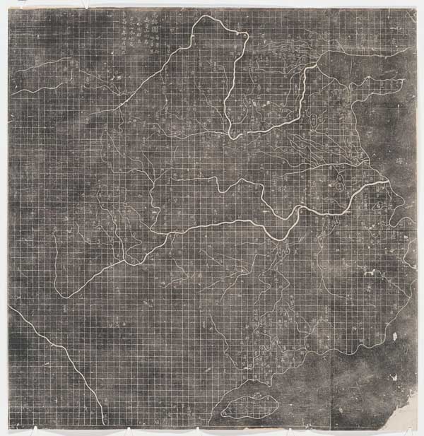
Map of the Tracks of Yu, rubbing from a 1136 stone carving (Xi’an, Stele Forest Museum), 19th century (rubbing), 81 x 78.5 cm, Fine Arts Library, Harvard University, Rubel Collection Accession F-06.
G.3.1 Ordering the State: Inner and Outer Borders in Chinese Maps from the Southern Song Dynasty (1127-1279)
Julia Orell, University of British Columbia
China’s Southern Song dynasty (1127-1279) was a time of intense engagement with geography, especially historical geography, resulting in the production of a wealth of printed materials. Maps are included in illustrated local and regional gazetteers, atlases show the Chinese empire throughout history, and discussions of ancient geographical treatises use maps to make arguments about the interpretation of textual information. My paper explores if and how borders were represented in a selection of these materials by examining both the outer borders of the Chinese empire and the internal borders between administrative units (circuits, provinces, counties).
Cartographic representations did not follow a standardized set of conventions at the time, so that different modes of representing borders – or not showing them at all – co-existed, which speaks to a more fluid notion of “border” than found in modern cartography. While clearly demarcated, linear borders were essential during this time of military conflicts with neighbor states and subject to complex negotiations, maps are often ambiguous about showing and locating borders. For instance, depictions of the Great Wall in maps served as an “imaginary” northern border that did not correspond to a built structure or actual state borders. In addition to printed maps, my paper also discusses a twelfth-century handscroll painting that depicts the upper reaches of the Yangzi River in Sichuan province with inscribed place names. This painting includes “demarcations” of administrative borders (between counties) in textual form, floating in an undefined space above the river scenery. By examining these Song dynasty cartographic materials, I argue that the notion of border shifted, depending on the type of map, its intended audience, and political agenda.
Julia Orell is a historian of Chinese art, whose research focuses on landscape painting of the Song and Yuan dynasties (tenth to fourteenth centuries), with a specific interest in the depiction of place, site, region and empire. Her work explores painting as a participant in geographical discourse and knowledge production, and she is currently working on a book manuscript tentatively titled Mountains and Rivers Do Not Change: Landscape Painting, Geography, and Cartography in Mid-Imperial China. A second research area is in the historiography of East Asian art, focusing on late nineteenth and early twentieth century German-language scholarship. She received her PhD from the University of Chicago, taught at the University of Zurich, and held postdoctoral fellowships at the Getty Research Institute (Los Angeles) and Academia Sinica (Taipei). She is currently assistant professor at the University of British Columbia, where she teaches Chinese art history.
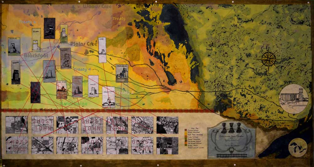
Grain Elevators of Saskatchewan. 39 x 74 inches. Watercolour and gouache on paper, 2020.
G.3.2 Outposts, Arteries and Borders: A Mapping of Rural Saskatchewan Grain Elevators
Elizabeth Whalley, Visual Artist
The iconic image of the grain elevator silhouetted against an empty sky embodies a certain unbounded vision of the Canadian west. For this session about the representation of borders in cartography, I will present a map whose borders frame and compartmentalize a vast imperialized and colonized region stretching from the eastern border of Alberta to the western shore of the Great Lakes and that includes what we now know as Saskatchewan. The map’s network of borders implicates outpost grain elevators, arteries of railways, as well as various political and geographic borders. Borders on my map suggest that they can be ephemeral, arbitrary, and fuzzy. Territories of indigenous people, the Medicine Line, boundaries of ghost towns, abandoned railway lines and the definition of geographical ecosystems defy permanent and precisely drawn borders. The narrative of the colonial history that the map and its web of signifiers unpack about the isolated grain elevator becomes likewise blurred and ambiguous.
The process of mapping gives me, as an artist, a way to dig into the meanings behind the aesthetics of the individual elevator and dramatic western spaces. By changing my perspective from the “street view” of the grain elevator against the sky to the disembodied surveillance perspective of “satellite view,” I transform a personal impression into an analysis of ongoing natural and man-made systems. By drawing borders that quantify and categorize ecosystems, regions of exploitation, and points of control I call up issues of territorialization, ownership, and political power. Through mapping I infiltrate the disciplines of geography, economics, and history to show that not only grain elevators of rural Saskatchewan, but also the communities that depended on them, and the railways that connected them to Eastern markets, are a part of the armature of colonization used in the process of creating the Canadian state.
Elizabeth Whalley is a Canadian visual artist based in Quebec and Nova Scotia. Working at the intersection of traditional and experimental media, she creates projects, often collaboratively, that query our relationship to the material world. Her studio practice engages drawing, painting, printmaking, mapping, writing, digital media, and performance. She has exhibited her work in Nova Scotia, Quebec, and New York. She has taught fine arts as adjunct faculty at Adelphi University, Haverford College, Pratt Institute, and Brooklyn College. She received her MFA and an Advanced Certificate in Performance and Interactive Media Arts from Brooklyn College, City University of New York. Academic conference participation includes, in 2017, Landscape: Notes from the Field, as part of the ARTexchange, at the College Art Association Conference in New York and, in 2015, The Classicized Imagination as part of the conference in honour of George Whalley, Awake to Love and Beauty, at Queen's University.